

WEATHER CHANGE
(1) The hourly rain and wind barb
Wind has been identified, which shows a low pressure pattern due to heavy precipitation and typhoon. In particular, a noticeably large amount of precipitation was found near the center, which is a characteristic of typhoons.
Furthermore, precipitation was observed up to 45mm near the eye of the typhoon, and considering the extent of the typhoon's impact, heavy precipitation is expected throughout the Korean Peninsula. And the maximum wind speed outside the center is expected to be more than 12 m/s, so much higher wind speeds are expected near the center.

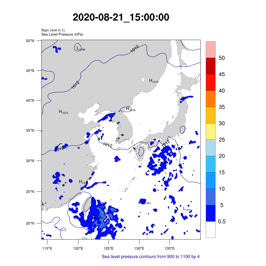
(2) The hourly rain and Sea level pressure
As expected, the typhoon's path and SLP moved together. As the typhoon developed, it was identified that it rained the most on the Korean Peninsula around the afternoon of August 26. The SLP was represented by an isometric pressure line, indicating that the gap was narrowing as the typhoon approached the center. Simulated at six-hour intervals, the lowest atmospheric pressure was about 953 hpa.
(3) Temperature at 850 hPa
This simulation shows the direction of the typhoon. From August 22, the center of the typhoon and the shape of the typhoon could be identified, and vigorous temperature changing occurred during the day time than in the early morning hours.

(4) The Change of Mean Precipitation in Korea
We drew time series plots about the Korea grid index. This graph means the change of mean precipitation in Korea. We can see the max mean precipitation is shown on 2020-08-26 12:00:00 (in x-axis, 120). It is the time when BAVI arrived at the south edge of Korea. It recorded about 1.25mm of precipitation, and then rapidly decreased as BAVI disappeared in the Korea index.

(5) The Change of Mean Wind Velocity in Korea
This graph means the change of mean wind velocity in Korea. And it is described with sea level pressure, also. The red one is about v-component wind, which crosses south-north ; the blue one is the u-component which crosses west-east ; and the thin black one is sea level pressure.
South and east winds were blowing until the typhoon moved northward and the Korean Peninsula entered the typhoon's influence. We can see that the typhoon approaches Korea by observing low sea level pressure.
From the 25th, when Korean Peninsula was close to the influence of the typhoon, until noon on the 26th, when the typhoon almost passed, there were north and east winds in Korea. Since then, as the typhoon has passed (disappeared), we can see that there are approximately west and south winds blowing in Korea and sea level pressure is also increasing.

(6) The Time Series Graph of Temperature
& SLP Change at the Eye of Typhoon BAVI
If you look at the time series graph below, you can see that the temperature near the surface at the center of Typhoon BAVI is about between 26 and 30 degrees Celsius. It can also be seen that the ground temperature of the typhoon BAVI's eye drops sharply from around August 26 (about 120 hours after the start of the simulation).

This can be assumed as a result of the typhoon's landing on the Korean Peninsula at 12 p.m. (9 p.m. Korean time) on the 26th, which is the night when the temperature of the land has become lower than the temperature of the sea. (See the graph below for changes in water and land temperature during the day.)

Data From: http://gsp.humboldt.edu/OLM/Courses/GSP_216_Online/lesson8-1/interpreting-imagery.html.
The SLP time series graph at the center of Typhoon BAVI shows that SLP continuously decreases over time and then increases again from about 100 to 120 hours after the start of the simulation. Based on this, it can be assumed that the typhoon's strength has gradually strengthened since the outbreak, but its status has weakened as it approaches the Korean Peninsula.

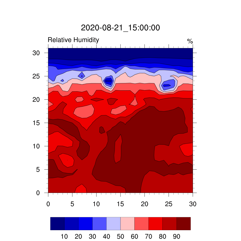
(7) The Vertical Relative Humidity Change
Looking at the time-varying graph below, we can see that showing uniform relative humidity distribution at first, but rapidly decreasing relative humidity near the center of the typhoon after the BAVI occurrence and became funnel shape on the graph. (In this graph, the center of the typhoon is located at 15 on the horizontal axis.)
Over time, the distribution of water vapor around the typhoon fluctuated, but the low amount of water vapor distribution in the form of a funnel can be found to be relatively maintained near the center of the typhoon. In addition, such forms appear to collapse in the evening of August 26 and around the 27th, when the typhoon is running out of steam.
(8) The Vertical Wind Distribution of BAVI
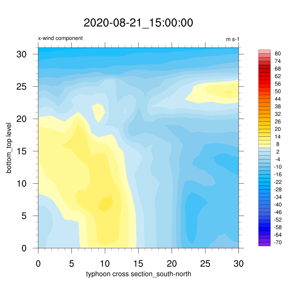
(a)
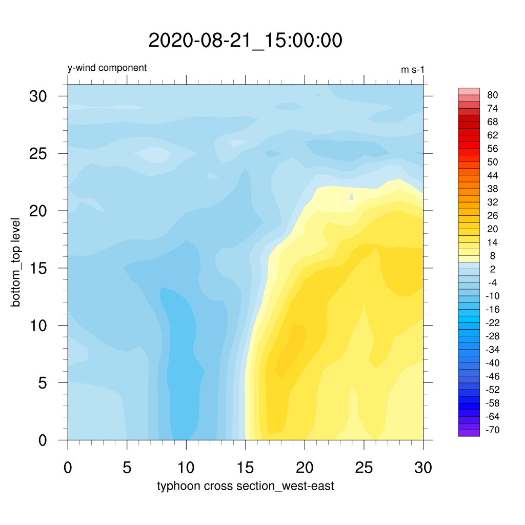
(b)
(a) is vertical distribution of u-wind (x-component) animation , and (b) is vertical distribution of v-wind(y-component) animation
This graph (gif) shows the vertical wind change (of u, v components) of typhoon. We chose different typhoon cross sections for each wind vector ; by south-north to x-component ; by west-east to y-component. In both wind animations, there are clear differences centered on typhoon. Because the typhoon is the thing that a whirlwind rotates in a circle, it can be seen that the opposite direction wind appears based on the center. From the 2020-08-23, it can be seen that the wind becomes stronger, and after, becomes weak as the typhoon disappears. And we also can check that velocity intensity from the center of the typhoon drawn below.

Image from : https://images.app.goo.gl/X1F7vsBFTCBaCWrt8
(9) The Vertical Temperature Distribution of BAVI
This .gif shows us the vertical temperature change of the typhoon. We chose the cross section of the typhoon by both west-east and south-north. In both, we can find that the temperature is layered according to altitude, and the strap structure is almost stable except for the center and its nearby. However, in the west-east section, a sharp drop in temperature is found next to the center. The change of temperature is vigorous at the center of the typhoon, and the temperature is high also at the center. Furthermore, in both, when the time the typhoon disappears is coming, it is observed that the closer the surface, the more fluctuating the temperature.

(a)
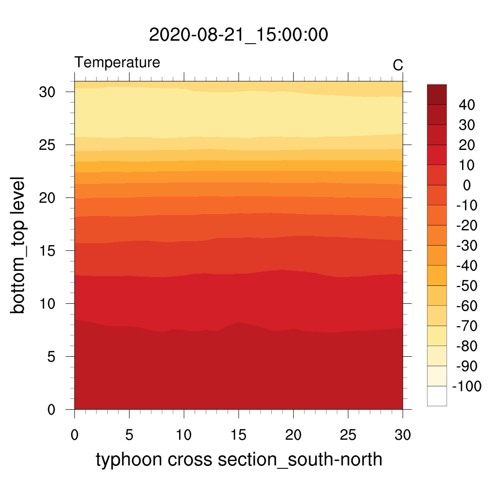
(b)
(a) is vertical distribution of west-east section animation , and (b) is vertical distribution of south-north section animation